A road that paid for itself.
Huizhou produced little food and a great many merchants. When the Hui traders secured a monopoly on salt in the Liangzhe region during the Ming and Qing, money moved — and so did people, in both directions, along a single practical corridor to Hangzhou. The Hui–Hang road is what that corridor looked like before there were roads: about 20 km of stone paving across the watershed, shorter by some 50 km than going round by the Yuling pass.
It is often introduced as the third of China’s great ancient trade routes, after the Silk Road and the tea-horse road. That ranking is promotional rather than historical, but the underlying claim holds: this is a merchant road, cut and maintained by the people who used it, and the inscriptions along the way are mostly donor records rather than scenery.
What you walk today is largely that same paving. The stretch inside Jixi county is the best preserved, and in 2013 it was listed as a national heritage site — significant, because it recognises the road itself as the monument rather than any building beside it.
The stages, west to east.
Walking from the Anhui gate toward Zhejiang is the conventional direction and the one described here. Done over two days it is about 16 km of walking; the full corridor from gate to gate is roughly 20 km.
Jiangnan village to Jiangnan First Pass
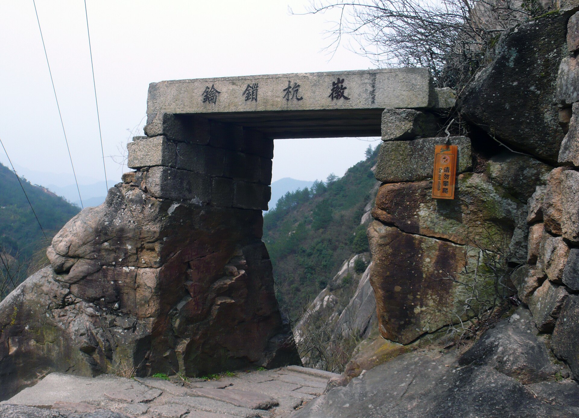
2.5 km · 1,400 steps · the gateThe walk starts on the valley floor at Jiangnan village in Fuling, Jixi, and almost immediately turns upward. Jiangnan First Pass is a stone gateway set into the cliff at about 424 m; the 1,400-odd steps below it are the single hardest sustained climb of the route. The gate’s name is a boast — it claims first place among the passes of the south — but it earns the stonework.
On to Huangmaopei
2.5 km · contouring · the tea stopBeyond the gate the road levels into a contour through bamboo and broadleaf, with the Shicha pavilion — a tea shelter where travellers were once given free water and tea — facing the Fozhang peak across the valley. Huangmaopei is a small settlement with a handful of basic places to eat. This is where the climb stops being an event and becomes a rhythm.
Xiaxuetang
Around the 5 km mark · bedsThe main overnight stop on the Anhui side, and the reason most people walk this in two days rather than one. Rooms are simple village guesthouse standard — shared and private, with meals. Book ahead in spring and autumn; the village has limited beds and the road is popular with domestic walking groups at weekends.
Lantian’ao
1,050 m · the high pointA broad grassy saddle on the provincial divide, and the highest point of the whole route. On a clear morning the ridges run out in both directions; on most mornings there is cloud, which is why the photographs of this spot tend to look better than the average visit. There is camping and simple lodging here as well as at Xiaxuetang, which splits the second day differently.
Down to Yonglai
The Zhejiang side · descentThe eastern descent drops through forest to Yonglai village in Lin’an’s Qingliangfeng township, where the road meets the tarmac. Note the asymmetry of the two ends: the Anhui gate is the standard entrance, while the Zhejiang entrance is ticketed as a combined ticket with the Zhexi Tianchi area and costs substantially more. If you are walking one way, start in Anhui.
Know before you go.
Two entrances, two prices
The Jixi gate is the one most walkers use. Adult admission is published at ¥62, with a lower price if booked online in advance, half price for students, and a ticket valid for two days — useful if you are sleeping on the mountain. The Lin’an entrance at Yonglai is sold as a package including the Zhexi Tianchi scenic area and is priced well above the Jixi gate. Confirm which ticket you are buying before you commit to a direction.
Opening hours are not uniform
Official notices for the Jixi gate give 08:00–16:30, with last entry at 16:30. Several commercial listings still show 06:00–18:00. Assume the shorter window and arrive early: reaching Xiaxuetang before dark is the difference between a pleasant first day and a rushed one.
Where the luggage goes
You cannot take a suitcase over the pass comfortably. Leave large bags at your Jixi hotel or with the driver, carry a day pack for the night on the mountain, and have the vehicle meet you at Yonglai. Guesthouses at Xiaxuetang provide bedding and meals; they do not store luggage for people who are not staying.
Rain changes the difficulty
The paving is polished and cambered. In dry weather it is a pleasure; after rain the descent from Lantian’ao becomes slow and the stone steps at the pass demand attention. Winter ice on the north-facing sections has closed the route in the past. Check conditions rather than trusting a summer photograph.
Two ways to walk it.
Both are outlines to adapt, not fixed departures. Opening arrangements, ticket prices and which sections are open are confirmed for your dates.
- Two days, one night. Arrive Jixi the evening before and stay near the trailhead. Day one: Jiangnan village to Xiaxuetang, 10–12 km with the pass steps behind you. Day two: an early walk to Lantian’ao for the high point, then the descent to Yonglai and a transfer out. This is the version that gives the road its proper time.
- One day, out and back. From the Jixi gate, climb to Jiangnan First Pass and continue to the Shicha pavilion, then return the same way — roughly 10 km and 4–5 hours. You see the best stonework and the hardest climb, and you skip the saddle. Suitable for a family with older children, or as a leg-stretch between other places.
Either version pairs naturally with the Zheling road to the west, which is free, quieter and 1,400 years old — the most useful contrast to this one.
Prepare for the actual route.
Shoes with a soft rubber sole and some tread; the stone is smoother than a mountain path and rewards grip over ankle support. One walking pole is genuinely useful on the descent. Carry a litre of water, cash for the villages, a warm layer for the saddle and a waterproof — the pass makes its own weather. A head torch matters if there is any chance of arriving at Xiaxuetang after dusk.
For a quote, tell us your dates, group size, whether you want one day or two, and where you are coming from. Ask the proposal to separate the entrance ticket, the mountain accommodation, meals and any vehicle transfer, because those are the four costs that vary most between operators.
Your questions, answered.
Do I need a guide?
No. The route is well waymarked and follows one line. A guide adds the merchant history and the inscriptions, which are the part most walkers walk past.
Can I walk it in reverse?
Yes, but the Zhejiang entrance is priced as a combined ticket and is less convenient for onward transport. Reverse it only if your itinerary demands it.
Is one day enough?
Enough for the pass and the best paving, not enough for the saddle. If the high point matters, take two days.
How busy does it get?
Busy by Chinese long-distance-trail standards, especially at weekends in April and October. Weekday walking in May or September is considerably quieter and the light is better.
References & photography.
Distances, pass altitude, step count and heritage listing follow the scenic area’s published information and the 2013 State Council listing of the Jixi section. Ticket prices and opening hours are indicative and change between seasons and sales channels.
- Jiangnan First Pass: about 424 m, roughly 1,400 stone steps.
- Lantian’ao: 1,050 m, the route’s high point.
- National 4A scenic area, 2011; seventh batch of national key cultural relics, 2013.
- Photo: 三猎 · Shicha pavilion on the Hui-Hang trail · CC BY-SA 4.0. Resized by Wikimedia.