A road for officials, then for rice.
The Zheling road has four other names and a single purpose. It carried officials, dispatches and tax grain between the Huizhou prefecture seat at Shexian and the Ningguo prefecture to the north-east — the “Huining official road,” in the language of the county records. Local tradition credits its cutting to Wang Hua, the late-Sui leader who held the region before submitting to the Tang and was later ennobled as the Duke of Yue. That dates the road to roughly 1,400 years ago.
Its height came later. When Huizhou merchants began moving grain, salt and mountain produce in volume, the same road became the freight corridor, and the village of Chatan halfway up acquired the nickname “the street in the sky” — at one point the largest rice market in the prefecture. The paving you walk is the physical record of that shift: wide enough for a shoulder pole and two porters passing, cut in slabs that have been worn round rather than broken.
Unlike the Hui–Hang, this road never became a ticketed attraction. It is a 3A scenic area on paper and a provincial heritage site in fact, but there is no gate, no closing time and no entrance fee. Local government money has gone into signage, car parks and a handful of pavilions rather than a visitor centre.
The stages, east to west.
Described from the Shexian side, which is how most walkers do it and the direction that puts the climb first. The full corridor between the two trailheads is about 20 km.
Xucun and Maoshe
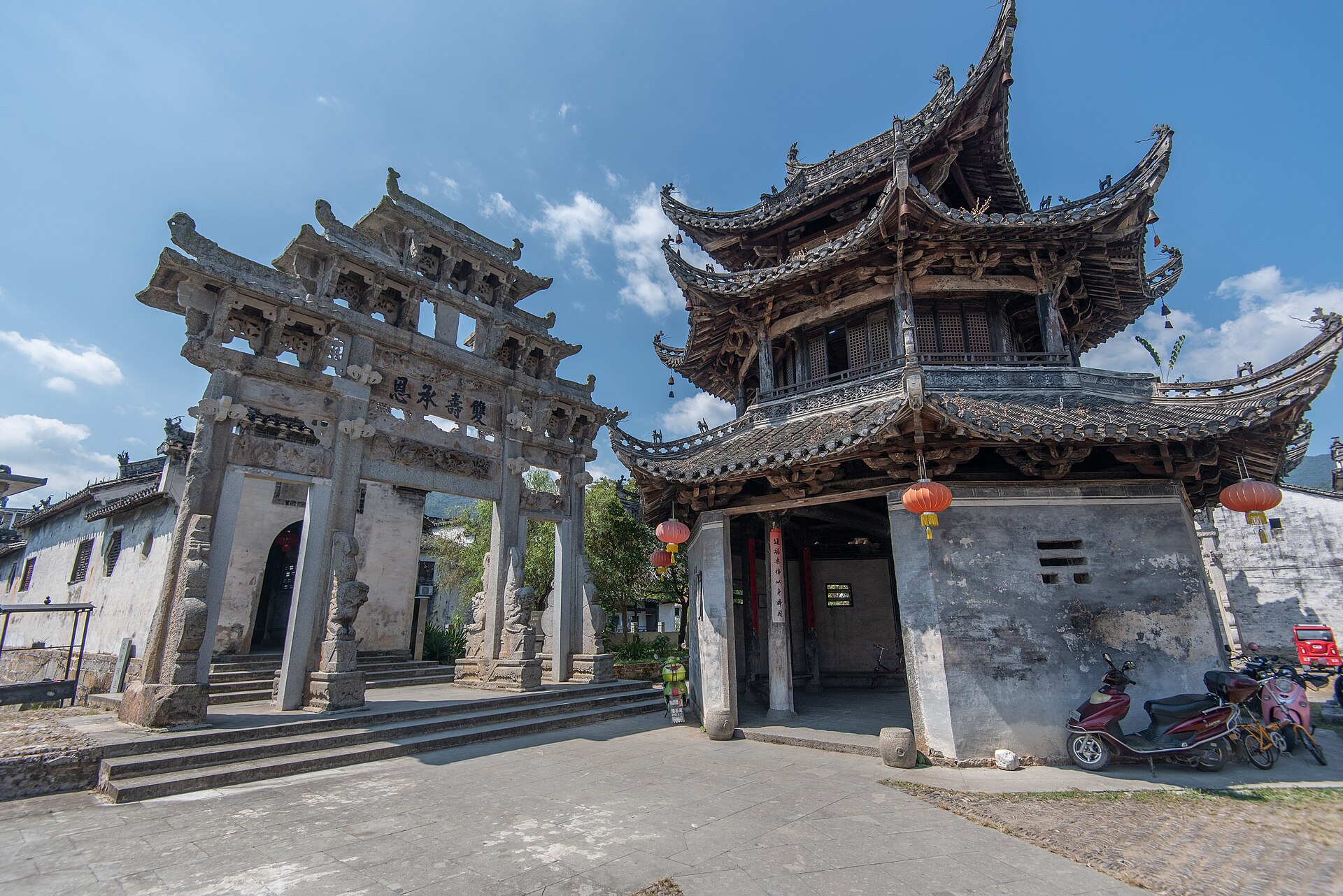
Start · village level · stone underfoot immediatelyXucun is the practical base: a national historic village with a walled cluster of Ming and Qing halls, memorial arches and a tiered pavilion, listed as a national heritage site in 2006. From Maoshe, a small hamlet above the village, the paving begins at once and climbs through bamboo in a series of shallow steps — the first real ascent, and the section where the road most clearly reads as infrastructure rather than path.
Chatan
The old rice market · huts and terracesThe village that supplied the road. Houses sit below the track rather than beside it, stacked against the slope, and the terraces above were worked to feed travellers as much as residents. Very little of the market survives, but the position explains everything: this is the last flat ground before the pass, and the first after it.
The Zheling pass
998 m · the gate · “the pass opens again”Fortified in 1647, at the transition from Ming to Qing, when the new dynasty wanted the northern approaches to Huizhou controlled. The gate is a stone arch with four characters carved above it — tian xian chong kai, roughly “heaven’s danger opened again” — and a small shrine to Guandi once stood twenty metres to its east. The roof is gone; the walls are not. From the gate the ground falls away north toward Taiping and east toward Jixi, which is why the site was chosen.
Tianxing cave and the descent to Gaojia
The Jingde side · caves, shrines, steps downBelow the pass on the northern side the road passes a sequence of named caves and shrine sites — Wuli, Kaobi, Wangzi, Tianxing — cut or built into the rock at intervals of a kilometre or so, each with its own small history of shelter and offering. The descent to Gaojia in Jinde county is steady and, in wet weather, slippery in a way that rewards attention rather than speed. The Jingde side climbs about 600 m over its first four kilometres if you walk it in reverse.
Know before you go.
Two trailheads, one pass
The eastern start is Maoshe, above Xucun in Shexian. The western start is Gaojia in Jinde’s Baidi township. They are about 20 km apart on foot and considerably further by road, because the road goes around the mountain rather than over it. Arrange a pick-up at the far end or plan a return the way you came.
No ticket, no facilities
There is no entrance fee and no staffed facility on the route. Signage has improved and the main junctions are marked, but the paths through Chatan and the upper terraces can be ambiguous in mist. Carry water from Xucun or Gaojia; the villages on the way have very limited supplies and not all take mobile payment.
Winter has become the season
Snow on the pass has made this a winter destination locally, with visitor numbers climbing in recent years — the village reports more than 20,000 a year and seven guesthouses. That is good for the village and bad for solitude on a snowy weekend. Ice on the north side is the genuine hazard.
Combine it with Xucun
The village is not a staging post to be hurried through. The halls, the arches and the water system are the reason the road exists, and a half day there before or after the walk changes what you notice on it. See our village walks guide for how to spend that time.
Three ways to walk it.
Outlines to adapt rather than fixed departures. Access, seasonal conditions and the state of the paving are confirmed for your dates.
- The crossing, one day. Start early at Maoshe, climb through Chatan to the pass, then descend the northern side to Gaojia. Around 20 km and 6–7 hours for a steady walker. A vehicle at Gaojia is essential; there is no convenient public connection back over the mountain.
- The pass and back. Maoshe to the gate and return, roughly 12–14 km. This gives you the climb, the market village and the gate without the long northern descent, and it is the version that works with a half-day transfer on either side.
- Two days with Xucun. Walk up to Chatan or the pass on day one and stay in Xucun that night, then spend the second morning in the village halls and lanes. The most rewarding shape if the history is the reason you came.
For contrast, the Hui–Hang Trail is the same age of stone with a ticket gate and a much larger crowd. Walking both in one trip is the clearest way to see what commercialisation does to a road.
Prepare for the actual route.
The surface here is older and more uneven than the Hui–Hang: slabs set at angles, edges lifted by roots, long flights without a riser. Shoes with grip and a little cushioning, one pole for the descent, and a waterproof that will survive being worn all day. Mist is common above 700 m and the pass can be several degrees colder than Xucun.
If you want a quote, tell us your dates, group size and whether you want the crossing or the return walk. Ask the proposal to distinguish the vehicle transfer, any guide, and meals in Xucun — the walking itself carries no entrance cost, so those three items are the whole budget.
Your questions, answered.
Why is it free when the Hui–Hang is not?
Different administrative history. The Hui–Hang was developed as a 4A scenic area with an operating company; the Zheling is managed as a heritage and rural-revitalisation asset, with public money spent on access rather than on ticketing.
Is it as good as the Hui–Hang?
Better stone, better history, fewer people. Worse logistics and less signage. If you only walk one and want an easy day, take the Hui–Hang; if you want the road itself, take this one.
Can I do it as a day trip from Huangshan?
Yes. Xucun is within reach of the Huangshan urban area by road. Start early, walk to the pass and back, and be in the village by late afternoon.
What about the other names?
Zheling, Jingxi, Huining, Suitang and part of the Huiqing road all refer to this corridor or sections of it. Local usage varies by county — Shexian says Zheling, Jinde says Jingxi.
References & photography.
Length, trailheads, pass altitude and heritage status follow Jinde county government and Anhui provincial reporting; the history of the road draws on county gazetteers and local heritage records.
- Jinde County Government: the Jingxi road from Gaojia through Tianxing cave to Maoshe and the pass, about 20 km.
- Zheling pass: 998 m, fortified 1647, inscription “tian xian chong kai”.
- Xucun historic village: national key cultural relics, sixth batch, 2006.
- Photo: Siyuwj · Xucun village, 2021 · CC BY-SA 4.0. Resized by Wikimedia.